
Tour Leader – Mark Imhof, Department of Economic Development, Jobs, Transport and Resources.
Introduction
Vegetable production is a common land use to the south east of Melbourne due to the friable and well-drained soils and access to markets. However, competing influences of urbanisation as well as degradation of waterways and Western Port coastal and marine (Ramsar) habitats mean that land managers need to modify management practices.
Delegates will visit a Water Corporation field site to look at issues associated with the application of nutrient rich recycled water and bio-solids to land. We then move through a rapidly urbanising vegetable cropping region to hear about recent research investigating nitrogen use efficiency and nitrous oxide emissions.
After lunch at a local bay side town, the tour will look at a new catchment-based water stewardship program involving horticulture and industry partners. We conclude with a visit to Moonlit Sanctuary Wildlife Conservation Park.
Itinerary
| 7:45am | Meet outside Gate 3 at the Melbourne Cricket Ground (MCG) |
| 8:00am | Depart MCG |
| 9:00am | Arrive at South East Water Bald Hill Farm |
| 10:00am | Depart South East Water for Devon Meadows |
| 10:30am | Arrive at Horticulture property at Devon Meadows |
| 11:30am | Depart Devon Meadows for Harewood Historic Homestead |
| 11:40am | Harewood Historic Homestead |
| 12:30pm | Lunch at Tooradin |
| 1:00pm | Western Port Biosphere and RAMSAR Project, Tooradin |
| 1:25pm | Depart Tooradin for Peninsula Fresh Organics |
| 1:45pm | Peninsula Fresh Organics, Baxter |
| 3:15pm | Depart Peninsula Fresh Organics for Moonlit Wildlife Sanctuary |
| 3:30pm | Arrive at the Moonlit Wildlife Conservation Sanctuary |
| 5:00pm | Depart Moonlit Wildlife Conservation Sanctuary for MCG |
| 6:00pm | Arrive Melbourne Cricket Ground (MCG) |
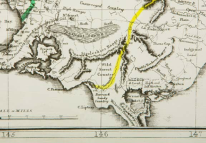
Port Phillip and Westernport Region
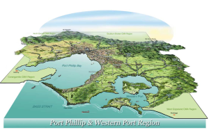
Click for larger image
Tour 3 Map
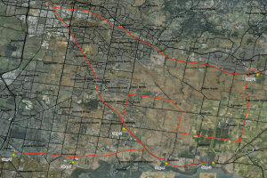
Click for larger image
Bald Hill Farm Water Recycling Plant
Bald Hill Farm Water Recycling Plant
Recycled water use and biosolids application – Suprapaneni and Goddard (Recycled Water Use and Biosolids Application report)
Bald Hill Farm, owned by South East Water is located to the north of the Pakenham Water Recycling Plant and to the south east of the Pakenham township. The farm is approximately 182 ha, of which 40 ha is used as a winter storage reservoir with the remainder available for agricultural production.
Fodder crops (pasture silage and hay) are produced on the farm, which is also grazed periodically by dairy stock and beef cattle. Recycled water is supplied to the property from the reservoir and is applied via three irrigation pivots (one 360o and two 180o) and one high pressure travelling gun irrigator. Approximately 100 ha is irrigated with the remainder under dryland agriculture.
In addition to use of recycled water, various sections of Bald Hill Farm received either single or repeat application of treatment grade 1 (T1) and contamination grade 2 (C2) biosolids from various South East Water Water Recycling Plants.
A flagship demonstration site was established in 2015 to showcase to farmers the sustainable management of biosolids. Soil health and agronomic data are monitored and presented to farmers at discussion groups
An annual environmental soil and groundwater monitoring program is in place to identify potential impacts to soils and groundwater from the use of recycled water and biosolids (Figure 1). Fifteen soil sample locations and four groundwater monitoring bores are located at the site. Soils are tested for pH, EC, sodicity, N, P, K, heavy metals.
Results – recycled water
Recycled water irrigation did not affect soil pH. Soil salinity was satisfactory and was well below the threshold level for pasture/fodder production. In their natural state the surface soils were generally non-sodic but became sodic with depth. Recycled water is expected to increase soil exchangeable sodium percentage. Gypsum application to minimize sodicity risks .resulted in decreased ESP levels after one application (5 t/ha) in April 2015. Soil Olsen P were much greater than agronomic recommended levels (Figure 2). Surface overland flow losses in heavier textured soils, or sub-surface flow in coarse textured soils could be a consequence of application of recycled water if this is not carefully managed. Available soil K was low. As expected soil total Kjeldahl N (TKN) showed no differences as this test is not suitable. Alternate tests for soil N may be required.
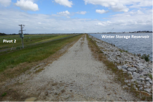
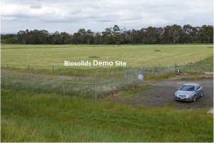
Figure 1 – Bald Hill Farm
Results – biosolids
The results of the two applications of biosolids (Table 1) showed that soil Olsen P levels are elevated and much greater than agronomic recommendations (Figure 3).
Table 1. Biosolids application details at the flagship demonstration site at Bald Hill Farm. (Click for larger image)
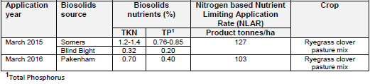
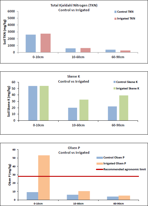
Figure 2 – Effect of recycled water irrigation on soil total Kjeldahl N, Skene K and Olsen P
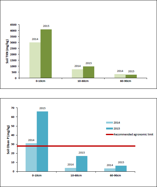
Figure 3. – Effect of biosolids application on soil total Kjeldahl N and Olsen P at the demonstration site (PA36), pre (2014) and post (2015) application.
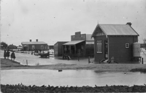
Koo Wee Rup - Region History in Pictures
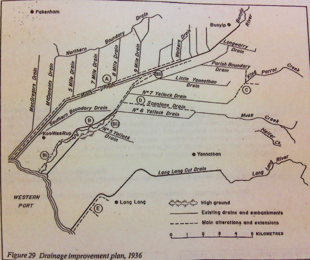
The History of the Koo Wee Rup Region
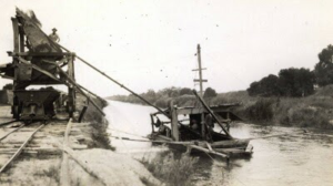
Main Drain Sand Dredging
The 'Great Swamp'
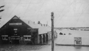
Koo wee Rup flood of 1934
Koo wee Rup flood of 1934
Cora Lynn flood of 1910
Cora Lynn flood of 1910
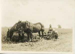
Horiculture - Devon Meadows
Devon Meadows
The second stop for the day is to a Horticulture property at Devon Meadows to discuss N use efficiency and greenhouse gas emissions in horticulture.
Presentations by Ian Porter, David Riches & Helen Suter.

Click for larger image
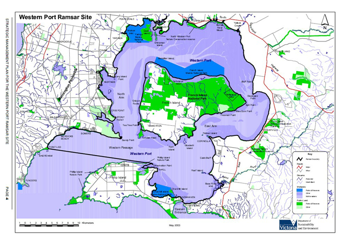
Tooradin - Western Port Ramsar Site
Tooradin – Western Port Ramsar Site
The Western Port Ramsar Site (listed in 1982) is located 60 kilometres (38 miles) southeast of Melbourne.
Covering around 60,000 hectares, Western Port is a coastal embayment incorporating vast mudflats, two sites of international, geological and geomorphological significance, and nationally important expanses of relatively undisturbed, species-rich, saltmarsh and mangrove vegetation. Western Port is located where the tidal range reaches a maximum on the Victorian Coast (up to 3 metres). For this reason, it is characterised by a wide variety of marine habitats ranging from deep channels to very extensive sea grass flats, fringing mangroves and saltmarsh and wide tidal mudflats.
An internationally important feeding and roosting area for numerous species of summering waders, many of which are listed under the bilateral Migratory Birds Agreements Australia has with Japan and China. Twenty-nine species listed under the Japan-Australia Migratory Birds Agreement (JAMBA) and 31 bird species listed under the China-Australia Migratory Birds Agreement (CAMBA) regularly occur in the Western Port Ramsar site. The significance of Western Port for migratory shorebirds has been recognised by its designation as part of the East Asian – Australasian Shorebird Reserve Network.
The site periodically supports over 10,000 waders and 10,000 ducks and swans, and a rich invertebrate fauna of 1,381 species. There is intensive use by commercial shipping. Human activities include recreation, commercial fishing, water extraction, and livestock grazing.
Reference – Strategic Management Plan for the Western Port Ramsar Site. Department of Sustainability and Environment 2003. http://www.depi.vic.gov.au/__data/assets/pdf_file/0003/242607/Western-Port-Ramsar-Site-Strategic-Management-Plan-SMP.pdf
Click for larger image
Port Phillip and Western Port Ramsar
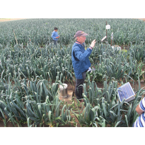
Sustainable Agriculture - Peninsula Fresh Organics
Sustainable Agriculture
Mornington Peninsula Vignerons Association
‘Compost Under Vine’ project seeks to show how using compost under grape vines in vineyards can lead to improvements in water use efficiency and soil health, reducing sediment and nutrient run-off into waterways.
Fruitgrowers Victoria
Compost trials were established in two pome fruit orchards to reduce water and herbicide use, improve soil health and reduce sediment and nutrient run-off.
Australian Native Food Industry Australia
Five Bush Food Workshops were held which focused on identifying, growing, harvesting and marketing bush foods, offering a diversified income as well as increasing biodiversity through native vegetation and creation of beneficial insectariums.
Vegetable Growers
‘Soil Wealth’ project trial site established that aims to reduce cultivation practices in the vegetable industry by demonstrating more sustainable production approaches using cover cropping, compost and minimum or no tillage practices.
Victorian Strawberry Growers Association
An update of the Environmental Best Management Practice Manual commenced and the manual will also be incorporated in modern communication format for growers to easily and readily access.
Balliang Food and Fibre Group
Nutrient budgeting trials are occurring with the aim of Balliang croppers adopting the practice of varying nutrient rates across paddocks to ensure that nutrient application is matched to the different soils and their requirements, reducing the use of fertilisers.
Farmer capacity-building events
The Regional Landcare facilitator helped run 15 farmer capacity building events for over 355 attendees, including
- 5 Bush Fod Workshops – 157 people
- Two ‘Preparing for Dry Conditions’ workshops – 50 people
- A ‘Results Day’ to highlight results of the ‘Compost Under Vine’ trial – 70 people.
Western Port Biosphere
Click below to download the presentation from Lance Lloyd.
Building a Water Stewardship community in the Western Port Biosphere
Pollutants in Watson Creek Catchment
Summary
The Watson Creek catchment contributes a high pollution load of nutrients and suspended solids to Western Port Bay. This pollution load is particularly significant as Watson Creek flows into the Yaringa Marine National Park (which forms part of the Western Port Ramsar Site) and is a risk to the biodiversity of the estuary.
Working in conjunction with staff in the Waterways Group at Melbourne Water, Sinclair Knight Merz (SKM) developed a conceptual model of possible pollutant pathways in Watson Creek catchment (SKM 2013). It was thought that diffuse pollution from market gardens were the main source of pollution (particularly nutrients) within the catchment, with some additional input from septic tanks, stock access and point pollution sources such as chicken or pig farms and tailing dams. However the role of groundwater in total catchment pollution loads is poorly understood.
For the current study, SKM was engaged by Melbourne Water to conduct a rapid field investigation of the movement of pollutants in the Watson Creek catchment. In particular, the current project aimed to identify areas of the catchment that may be contributing relatively more pollution than others, if possible to determine the source of that pollution (i.e. market gardens, septic tanks, chicken/pig farms), and to provide greater clarity about the interaction between groundwater and surface water in the catchment. Ultimately, this project aimed to increase understanding of the catchment in order to help inform the design and implementation of targeted intervention / treatment.
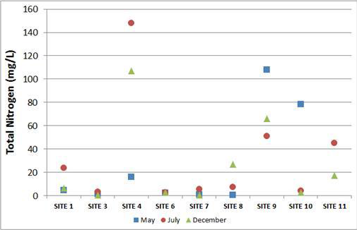
Results
Nutrients (nitrogen and phosphorus) were in high concentration in the catchment broadly. Total N concentrations were high in comparison to the SEPP guidelines (< 0.6 mg/L) in the main stem of Watson Creek, significant inputs are likely to be coming from point sources in the catchment, likely associated with irrigation of market gardens. The high Total Nitrogen concentrations consists primarily of the highly mobile and bioavailable nitrate species.
Microbial Source Tracking analysis and the stable nitrogen isotope analysis were broadly concordant. The results of the MST analyses suggest that there is overall a medium risk of faecal contamination in the catchment.
The isotope signatures for most sites point to a significant contribution from animal and human waste as the source, although commercial fertilisers may contribute.
Further, the extremely high nitrate concentrations recorded during both the May and July sampling events in the lower catchment had isotopic profiles that pointed to animal and human waste as the source.
This is a surprising result as it was expected that commercially produced nitrogen-based fertilisers could be a significant source of the nutrient contamination in the catchment. Considering that very high nutrient concentrations were recorded associated with likely irrigation activities, it is possible that the irrigation water itself could be a potential source.
Future investigation should be directed into the use of recycled water in the catchment. It is also possible that organic fertiliser (for example chicken manure) could contribute to the high nitrogen associated with the irrigation activities. Investigation of the use of this type of fertiliser in the catchment could also be informative.
Radon results indicate significant temporal and spatial variation in the groundwater/surface water interactions along Watson Creek. Only limited groundwater contribution is likely high in the catchment with more significant contribution lower in the catchment. No analysis was completed on the nutrient concentrations of the groundwater. While there is evidence that groundwater is contributing to the stream, we do not know from the current study if this groundwater contributes to the high nutrient load in the catchment.
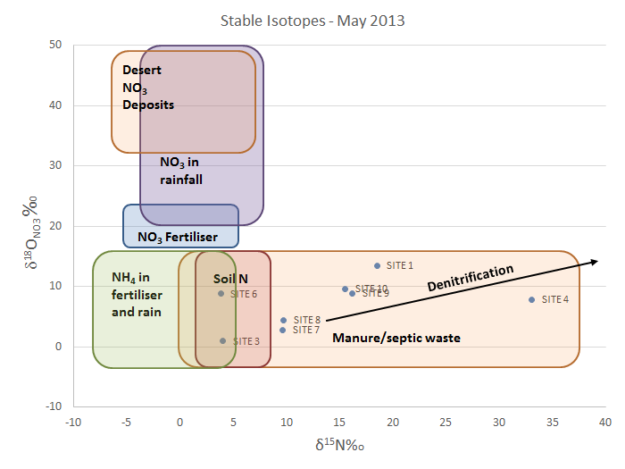
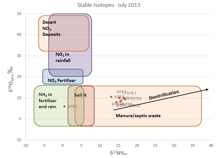
Nitrate isotopes for Watsons Creek for samples taken in A. 9 May 2013 and B. 31 July 2013. Superimposed on the graph are the typical ranges of δ15N and δ18O values for nitrate from various sources from Kendall (1998).
Enviroveg
Click on the link below to download the presentation by Wayne Shields and Lisa Brassington.
Moonlit Wildlife Conservation Sanctuary
Moonlit Wildlife Conservation Sanctuary
Melbourne’s award winning wildlife park, Moonlit Sanctuary Wildlife Conservation Park invites you to explore 10 hectares of bushland, meeting endangered species, feeding kangaroos and wallabies, petting koalas and enjoying encounters with colourful birds, reptiles, dingoes and many other animals.
Wander around our beautiful wetlands, a haven for water birds that change with the seasons. Meet koalas, kangaroos, wallabies, emus, Cape Barren geese and curlews, and stop past the wombats.
BY DAY…enjoy hand-feeding our gentle and curious wallabies and kangaroos, or cuddle one of our resident koalas.
Then pop over to the parrots and see orange bellied parrots, a critically endangered species; then visit the stunning red-tailed black cockatoos, gang gang, superb parrots, and the unique violet eyes of our bower birds.

What to bring:
- Hat
- Sunscreen (Some will be provided on board the coaches)
- Wet weather jacket
- Sturdy footwear (no open toe shoes)
- Money for the animal feeding or Koala experience at the Moonlit Wildlife Conservation Sanctuary